Prepper Gear
Survival Supplies and Know-How!

Welcome to Prepper Gear
Disasters and emergencies take many forms and can strike suddenly, without warning. Natural disasters include hurricanes, earthquakes, tornadoes, wildfires, floods and snowstorms. Man-made disasters and emergencies include terrorist attacks, power outages/blackouts, chemical spills, auto accidents, structure fires, and a host of other calamities.
1800Prepare.com provides quality survival and safety preparation gear, including a wide assortment of emergency preparedness kits, along with a vast selection of first aid supplies, emergency food and water, survival tools, emergency flashlights, radios and other critical items. Don’t wait until the next emergency strikes – get prepared now by visiting 1800Prepare.com!
GREAT DEALS:
Check out the best-selling Guardian Deluxe 2-Person Emergency Preparedness Kit from 1-800-prepare -- a $140 value, now just $70.99! Click now to get prepared for any emergency!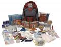 |
Guardian Deluxe 2-Person Kit $64.99 Item description (All items are packed securely in our Deluxe Hikers Backpack which contains extra space available for your personal items) The kit includes the following: Food and Water: 12 – Boxes of Aqua Blox Water Boxes – twice the amount of water as leading suppliers and has a 5 year shelf-life1 2 – 400 Calorie Food Bars – 5 year shelf-life (4800 Calories)20 – Water Purification Tablets – each tablet purifies 1 liter of water Light and Communication: 1 – Am/Fm Radio with Headphones and Batteries 1 – Rechargeable Squeeze Flashlight – 3 LED flashlight which generates and stores power by squeezing the handle (NO BATTERIES NEEDED) 1 – 30 Hour Emergency Candle – can also be used as a stove 1 – Green Emergency Glow Stick – lasts for 24 hours 1 – 5-in-1 Survival Whistle – compass, signal mirror, flint starter, waterproof container, lanyard, and shrill whistle 1 – Box of 50 Waterproof Matches 1- Bic Style Lighter Shelter and Warmth: 2 – Emergency Survival Sleeping Bags – Recommended over… |
NHC Atlantic Outlook


ZCZC MIATWOAT ALL
TTAA00 KNHC DDHHMM
Tropical Weather Outlook
NWS National Hurricane Center Miami FL
800 PM EDT Tue Jul 1 2025
For the North Atlantic...Caribbean Sea and the Gulf of America:
1. Near the Southeastern U.S.:
An area of low pressure could develop near the southeast U.S.
Atlantic or Gulf coasts over the weekend along a weakening front.
Although significant development is not anticipated, a tropical or
subtropical depression could form in this region over the weekend or
early next week while the system drifts and moves little. Regardless
of development, heavy rainfall is possible across portions of the
southeast U.S., particularly across the west-central Florida coast.
* Formation chance through 48 hours...low...near 0 percent.
* Formation chance through 7 days...medium...40 percent.
Forecaster D. Zelinsky
NHC Eastern North Pacific Outlook


ZCZC MIATWOEP ALL
TTAA00 KNHC DDHHMM
Tropical Weather Outlook
NWS National Hurricane Center Miami FL
500 PM PDT Tue Jul 1 2025
For the eastern and central North Pacific east of 180 longitude:
Active Systems:
The National Hurricane Center is issuing advisories on Hurricane
Flossie, located in the eastern Pacific basin, a couple hundred
miles offshore the coast of southwestern Mexico.
1. South of Southwestern Mexico:
An area of low pressure is forecast to develop several hundred miles
offshore of southwestern Mexico late this week. Environmental
conditions appear conducive for some gradual development of this
system thereafter, and a tropical depression could form over the
weekend while it moves generally west-northwestward.
* Formation chance through 48 hours...low...near 0 percent.
* Formation chance through 7 days...medium...40 percent.
Forecaster Jelsema
CPHC Central North Pacific Outlook
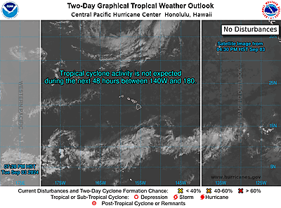
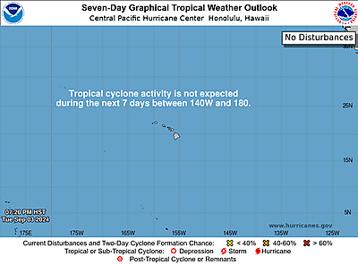
ZCZC HFOTWOCP ALL
TTAA00 PHFO DDHHMM
Tropical Weather Outlook
NWS Central Pacific Hurricane Center Honolulu HI
Issued by NWS National Hurricane Center Miami FL
200 PM HST Tue Jul 01 2025
For the central North Pacific...between 140W and 180W:
Active Systems:
The National Hurricane Center is issuing advisories on Hurricane
Flossie, located in the eastern Pacific basin, a couple hundred
miles offshore the coast of southwestern Mexico.
Tropical cyclone formation is not expected during the next 7 days.
Forecaster Jelsema